Inappropriate grazing/agricultural practices, fires, improper reforestation plans and expansion of urban/industrial areas often results in a reduction of the fauna/flora diversity and biological productivity. In this context, sustainable management of natural vegetation and agricultural areas plays an important role in supporting natural resources at globally significant scale.
The right spectral channels and spatial resolution of PRISMA could improve discrimination and changes in spatial distribution of individual species (forest, rangeland, invasive and crops) and the accuracy to estimate biochemical and biophysical parameters (Lee et al., 1999; Tian et al., 2001; Melgani and Bruzzone, 2004; Yang et al., 2010), allowing vegetation health and stress indicators evaluations and damage assessments. Moreover, significant improvement in mapping vegetation chlorophyll pigment and nitrogen could be provided by PRISMA.
PRISMA sensor, having a large number of narrow bands, could provide necessary information for measuring and mapping the soil physical degradation (soil condition and erosional state of bare soils); the soil texture (i.e. the relative proportions of clay, sand and silt) and the soil organic carbon (SOC) in agricultural fields that is important for the balance of greenhouse gasses (GHGs) and in studies dealing with the mitigation of climatic change (IPCC, 2001); the cropland biophysical variables such as Leaf Area Index (LAI) (Hansen, P.M. et al., 2003, Lee, K. Et al. 2004), Absorbed Photosynthetically Active Radiation (FAPAR) and chlorophyll a+b (Cab) (Chen and Cihlar, 1996; Myneni et al., 2002) useful to characterize crop status and estimate its productivity; the Land use/Land Cover types changes and the forest vegetation greenness.
PRISMA capabilities have been explored for mapping the human impacts on heterogeneous natural areas such as the Mediterranean environments. Maps generated by using hyperspectral data (Hyperion in this case) have the capability to effectively identify the occurred changes and to indicate more precisely where restoration or alteration of the vegetation covers are concentrated
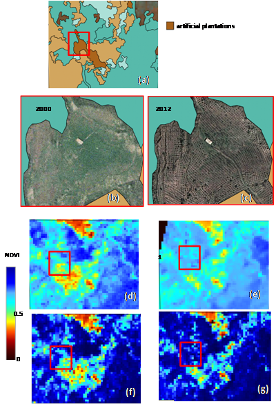 |
| Example of artificially wood-planted areas located in the North-Eastern part of Sicily (coloured in dark brown in the Forest Map of Sicily Region, see Box a)). NDVI maps from Landsat (acquired on 27 July 2003, Figure (d)) and ALI (acquired on 11 July 2012, Figure (e)) and from Hyperion (acquired respectively on 14 July 2003 and 26 July 2012, see Figures (f) and (g)) identify vegetation changes due to the establishment of these artificial plantations (not yet present in 2000, as shown in the orto-photos, see boxes (b) and (c)). NDVI range from hyperspectral data is larger than NDVI range from multispectral data allowing a better detection of the different stress/health conditions of vegetation covers, identifying more precisely pixels mostly involved in alterations/deterioration processes. |
In parallel, agriculture appears to be one of the key sectors that could greatly benefit from PRISMA mission. Agricultural management based on soil and crop status information, allows the reduction of the environmental impact linked to excessive use of limited resources such as water, as well as technical input factors such as fertilizers or herbicides, at the same time ensuring a profitable crop yield of high quality. PRISMA hyperspectral imagery will allow to obtain an accurate estimation of physical, biochemical crop and soil variables linked with agricultural management and its environmental impact. The presence on PRISMA sensor of numerous narrow bands in the SWIR region (1100 – 2500 nm) will warrant an accurate estimation of soil texture (i.e. the relative proportions of clay, sand and silt). In addition, organic matter, also expressed in soil organic carbon content (SOC), is a relevant variable in the quantification of the balance of greenhouse gasses (GHGs) and in studies dealing with the mitigation of climatic change
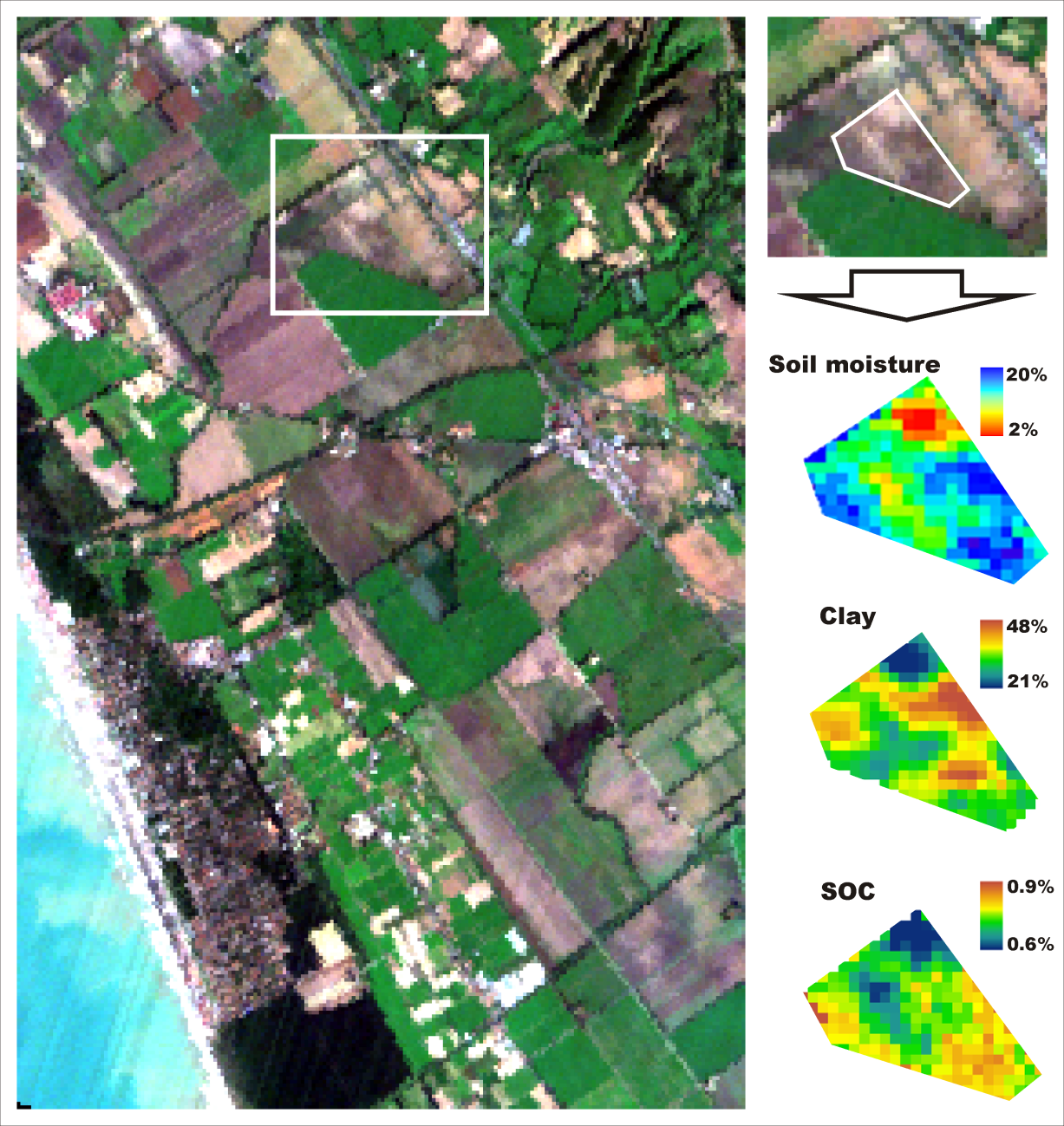 |
| Hyperspectral satellite image (Hyperion) acquired in Maccarese (Rome) and estimated soil variables maps concerning soil moisture, clay and soil organic carbon (SOC). |
References
[1] Chen J, Cihlar J, 1996. Retrieving leaf area index of boreal conifer forests using Landsat TM images. Remote Sensing of Environment, 55(2): 153–162.
[2] Hansen, P.M.; Schjoerring, J.K. Reflectance measurement of canopy biomass and nitrogen status in wheat crops using normalized difference vegetation indices and partial least squares regression. Remote Sensing of Environment, 2003, 86, 542–553.
[3] IPCC, 2001. Summary for policy makers. In: Houghton, J.T., et al. (Ed.), Climate Change 2001: The Scientific Basis. Contribution of Working Group 1 to the Third Assessment Report of the Intergovernmental Panel on Climate Change. Cambridge University Press, Cambridge, p. 944.
[4] Lee Z, Carder K, Mobley C et al., 1999. Hyperspectral remote sensing for shallow waters. 2. Deriving bottom depths and water properties by optimization. Applied Optics, 38(18): 3831–3843.
[5] Lee, K.; Cohen, W.B.; Kennedy, R.E.; Maiersperger, T.K.; Gower, S.T. Hyperspectral versus multispectral data for estimating leaf area index in four different biomes. Remote Sensing of Environment, 2004, 91, 508–520.
[6] Melgani F, Bruzzone L, 2004. Classification of hyperspectral remote sensing images with support vector machines. IEEE Transactions on Geoscience and Remote Sensing, 42(8): 1778–1790.
[7] Myneni R, Hoffman S, Knyazikhin Y et al., 2002. Global products of vegetation leaf area and fraction absorbed PAR from year one of MODIS data. Remote Sensing of Environment, 83(1–2): 214–231.
[8] Tian Q, Tong Q, Pu R et al., 2001. Spectroscopic determination of wheat water status using 1650–1850 nm spectral absorption features. International Journal of Remote Sensing, 22(12): 2329–2338.
[9] Yang F, Li J, Gan X et al., 2010. Assessing nutritional status of Festuca arundinacea by monitoring photosynthetic pigments from hyperspectral data. Computers and Electronics in Agriculture, 70(1): 52–59.